The Best Methods for Underground Utility Location
Digging without knowing what lies beneath can cause costly repairs, dangerous gas leaks, and power outages. Knowing where buried utility lines are is a requirement before any construction or excavation project. Below, we’ll discuss the best methods for underground utility location and the applications they suit best.
Why Underground Utility Location is Crucial
Accurately locating underground utilities prevents accidents and verifies the safety of workers and the public. Striking a gas line or damaging electrical cables can cause severe consequences, including injuries, service disruptions, and expensive repair costs.
In the United States, contacting 811—the free national before-you-dig service—before any excavation is legally required in most states. This action also triggers utility marking with paint or flags.
Damage trends are moving the wrong way. The CGA’s 2024 DIRT Report recorded its Index rising from 94.0 (2023) to 96.7 (2024). This data underscores how common strikes remain.
Beyond safety, proper utility mapping minimizes project delays and ensures compliance with local regulations. It also promotes sustainable practices by reducing unnecessary excavation and preserving existing infrastructure.
Techniques for Detecting Underground Utilities
Now that we understand the importance of underground utility location, what are the best methods? Electromagnetic locating, ground-penetrating radar, and acoustic location are all accurate and popular techniques for discovering what lies beneath the surface.
Once located, utilities are marked to the APWA Uniform Color Code—red for electric, yellow for gas, blue for potable water, and so on. Therefore, crews can read what lies below at a glance.
Method 1: Electromagnetic Locating
Electromagnetic (EM) locating is the most common method for utility detection. It relies on the electromagnetic fields metallic utilities emit or technicians induce. Special transmitters send signals through utility lines, creating detectable electromagnetic fields. Consequently, a receiver picks up these fields from the surface. This enables technicians to trace the path and depth of buried utilities such as metallic pipes, electrical cables, and telecommunications lines.
This method offers several advantages. EM locating equipment is portable and cost-effective. It allows experienced operators to quickly scan large areas with real-time results. However, EM locating has limitations. For instance, it struggles with non-metallic utilities like plastic water lines or fiber optic cables without using tracer wires.
Method 2: Ground-Penetrating Radar
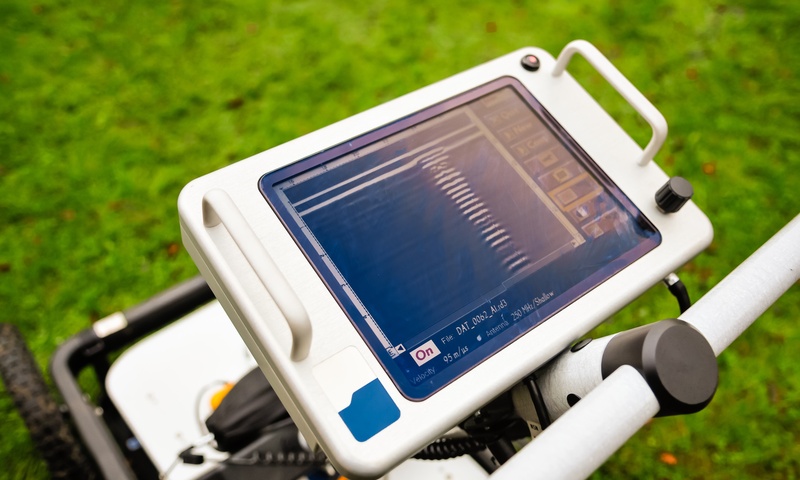
Ground-penetrating radar (GPR) is a highly effective and accurate method for determining the location of utilities and any objects beneath the surface. How ground-penetrating radar works is it sends electromagnetic pulses through an area and then measures the signals that reflect back.
GPR is especially effective at locating plastic pipes, concrete structures, and utilities in challenging soil conditions. It works well across various ground types, from sandy soils to rocky terrain. GPR also provides accurate depth measurements. However, wet or clay-heavy soils can reduce the penetration depth and signal clarity. In addition, interpreting the complex data requires skilled operators.
Method 3: Acoustic Location
Acoustic location uses sound waves to detect underground utilities, particularly pressurized systems like water and gas lines. By identifying the distinctive sounds that flowing liquids or gases create, technicians can locate pipes with sensitive acoustic equipment. This method is especially effective for active water services and pressurized gas mains. It even traces utilities by following sound patterns along pipe lengths.
One key advantage of acoustic location is its ability to detect plastic water lines and pinpoint leaks or operational statuses that other technologies might overlook. However, challenges for acoustic location include ambient noise from traffic or construction that can interfere with readings. Quiet conditions are crucial for accurate results. This means the method may not be effective in noisy environments.
Method 4: Vacuum Excavation (Soft Dig)
Vacuum excavation—often called soft dig or hydrovac—uses pressurized air or water and a vacuum to safely expose buried lines without damaging them. It is commonly paired with detection methods to verify a utility’s exact position and depth. Crews do this before mechanical digging begins.
Ensuring Accurate Underground Detection
Professional utility location uses multiple detection methods, such as GPR for non-metallic utilities, EM locating for metallic systems, and acoustic techniques to address gaps, ensuring comprehensive results. In addition, skilled technicians interpret complex data and provide detailed reports outlining utility locations, depths, and potential conflicts with construction plans. This ensures thorough planning and accurate documentation.
Best Practices & Regulatory Compliance
Before any excavation, always contact 811 (or your local one-call center) and wait for utilities to be marked—digging blind risks the very strikes this article helps you avoid. Respect the APWA color code so crews can read markings at a glance, and favor soft-dig or vacuum excavation when a line’s exact position is uncertain. Detection is only half the job: verifying locations on site and following local one-call and damage-prevention regulations keeps projects safe, on schedule, and compliant.
Would you like to receive similar articles by email?

Danuta Smoluk
Danuta Smoluk is a teacher with over three decades of experience teaching both children and adults. She specializes in teaching the Polish language to English-speakers. She has a master's degree in primary and early childhood education from WSP Słupsk (currently Pomeranian University in Słupsk) and had her degree validated by University of Toronto. Aside from education, she also has an interest in real estate and home improvement. She has planned and supervised many house renovations. She loves interior design, cooking, and gardening.


You May Also Like
Maximize Your Space: A Guide To Choosing Self Storage Units

The 10 Elements of Elegant Landscape Design